Explore the World of GPS Technology

GPS technology revolutionizes how we navigate, track, and manage mobile assets across industries. From satellite navigation to fleet management, GPS solutions provide precise positioning data that enables real-time monitoring and comprehensive operational control.

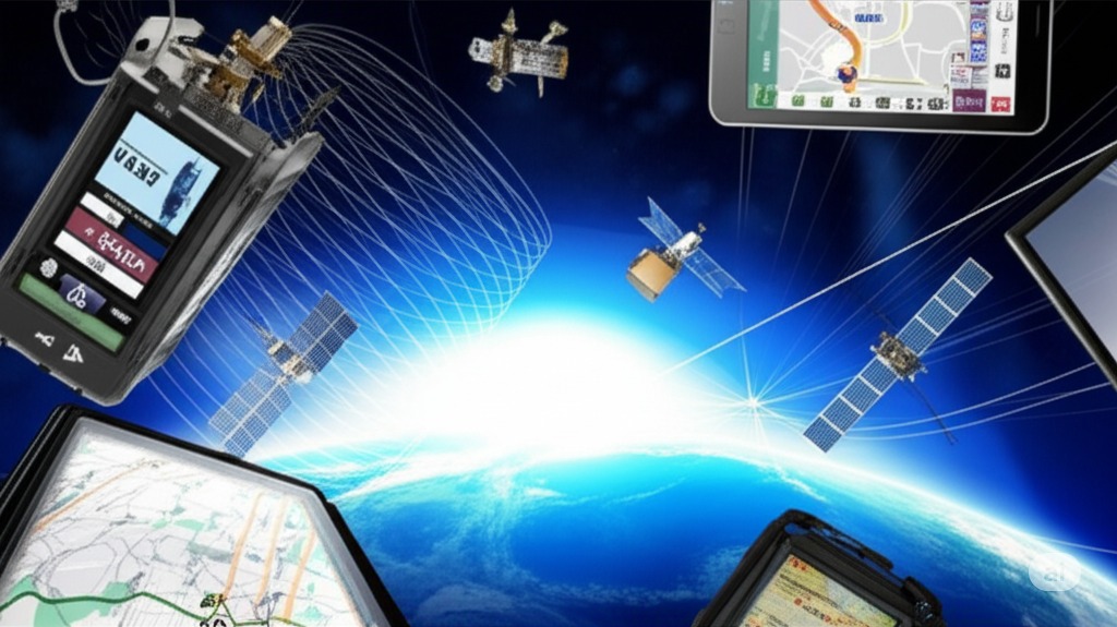
Core GPS Technology Components

  • 24+ satellites orbiting Earth providing global coverage
  • Ground control stations monitoring system accuracy
  • GPS receivers calculating precise position coordinates
  • Real-time data transmission and communication systems
  • Advanced algorithms for signal processing and triangulation
  • Atomic clocks ensuring nanosecond timing precision
  • Multi-frequency signals for enhanced accuracy
  • Integration capabilities with mapping and software platforms

GPS technology forms the foundation of modern navigation and tracking systems, enabling precise location services that power everything from smartphone apps to complex fleet management solutions worldwide.

GPS technology overview showing satellite navigation and tracking applications
Explore the World of GPS Technology - Professional GPS tracking and fleet management solution

GPS Solutions by Industry & Application

Professional GPS tracking solutions serve diverse industries with specialized applications. Business GPS systems optimize fleet operations, commercial solutions manage large-scale logistics, and asset tracking protects valuable equipment across multiple sectors.

GPS solutions across different industries and business applications
GPS Solutions by Industry & Application - Professional GPS tracking and fleet management solution

Industry-Specific GPS Solutions

  • Business GPS tracking for small to medium enterprises
  • Commercial fleet management for large-scale operations
  • Asset tracking for equipment and valuable property
  • Transportation and logistics optimization systems
  • Construction equipment monitoring and management
  • Healthcare mobile workforce coordination
  • Emergency services and public safety applications
  • Agriculture and farming equipment tracking solutions

Each industry benefits from tailored GPS solutions that address specific operational challenges, compliance requirements, and efficiency goals through specialized tracking and management capabilities.

How GPS Shapes Our World

GPS technology connects our global infrastructure through precise timing and positioning services. Twenty-four satellites orbiting Earth provide positioning data to billions of devices, enabling everything from smartphone navigation to critical infrastructure synchronization.

Global GPS Impact Areas

  • Smartphone navigation and location-based services
  • Aviation and maritime navigation systems
  • Financial transaction timing and synchronization
  • Telecommunications network coordination
  • Power grid timing and distribution management
  • Scientific research and geological monitoring
  • Emergency response and disaster management
  • Global supply chain and logistics coordination

GPS technology has become essential infrastructure that enables modern society to function efficiently, providing the timing and positioning foundation for countless applications that impact daily life worldwide.

GPS satellite constellation and global positioning network overview
How GPS Shapes Our World - Professional GPS tracking and fleet management solution

Advanced GPS Applications & Features

Modern GPS systems offer sophisticated features including real-time tracking, geofencing, route optimization, and predictive analytics. These capabilities transform raw location data into actionable business intelligence for improved operational efficiency.

Advanced GPS features and applications for fleet management and tracking
Advanced GPS Applications & Features - Professional GPS tracking and fleet management solution

Advanced GPS Capabilities

  • Real-time tracking with sub-meter accuracy
  • Geofencing and automated alert systems
  • Route optimization and traffic integration
  • Predictive analytics and reporting dashboards
  • Driver behavior monitoring and scoring
  • Maintenance scheduling and vehicle diagnostics
  • Integration with business management systems
  • Mobile applications and remote monitoring

Advanced GPS features provide comprehensive visibility and control over mobile assets, enabling data-driven decisions that optimize operations, reduce costs, and improve service delivery across all industries.

Frequently Asked Questions

Use Enter or Space to expand FAQ answers. Use Tab to navigate between questions.

GPS (Global Positioning System) is a satellite-based navigation system that provides accurate location and time information anywhere on Earth. Originally developed by the U.S. Department of Defense, GPS uses a constellation of at least 24 satellites orbiting Earth to triangulate precise positions for navigation, tracking, and timing applications worldwide.

GPS works through trilateration using signals from multiple satellites. GPS receivers calculate their position by measuring the time it takes for signals to travel from at least four satellites. The system determines latitude, longitude, altitude, and precise time by analyzing signal timing differences and satellite positions in space.

GPS accuracy typically ranges from 3-5 meters (10-16 feet) for civilian applications under optimal conditions. Professional and military GPS systems can achieve sub-meter accuracy. Factors affecting accuracy include satellite visibility, atmospheric conditions, signal obstructions, and the quality of the GPS receiver being used.

GPS consists of three main segments: the space segment (satellites), the control segment (ground stations), and the user segment (receivers). The space segment includes 24+ satellites, the control segment monitors and maintains the system, and the user segment encompasses all GPS receivers used by civilians and professionals.

GPS was developed by the U.S. Department of Defense, with key contributions from Ivan Getting, Bradford Parkinson, and Roger Easton. The project began in the 1970s, with the first satellite launched in 1978. The system became fully operational in 1995 and was made available for civilian use with varying levels of accuracy.

GPS is the American satellite navigation system, while GNSS (Global Navigation Satellite System) is the generic term for all satellite navigation systems worldwide. GNSS includes GPS (USA), GLONASS (Russia), Galileo (Europe), and BeiDou (China), providing users with more satellites and improved accuracy through multi-system receivers.

The GPS constellation consists of at least 24 operational satellites, with typically 30-32 satellites in orbit to ensure redundancy and global coverage. These satellites orbit Earth approximately every 12 hours at an altitude of about 20,200 kilometers (12,550 miles) in six orbital planes.

GPS types include Standard Positioning Service (SPS) for civilians with 3-5 meter accuracy, Precise Positioning Service (PPS) for military use with enhanced accuracy, and Differential GPS (DGPS) which uses ground stations to improve accuracy to sub-meter levels for professional applications.

Yes, GPS works without internet connection as it receives signals directly from satellites. However, many GPS applications require internet for map downloads, traffic updates, and location sharing. Offline GPS apps can function with pre-downloaded maps, making GPS navigation possible without cellular or WiFi connectivity.

GPS requires signals from at least 4 satellites to determine a precise 3D position. Three satellites provide latitude and longitude through trilateration, while the fourth satellite corrects for timing errors in the receiver's clock and provides altitude information, ensuring accurate positioning in three-dimensional space.

GPS signal strength is affected by atmospheric conditions, physical obstructions like buildings or trees, satellite geometry, receiver quality, and electromagnetic interference. Weather conditions, ionospheric disturbances, and multipath effects where signals bounce off surfaces can also impact signal quality and positioning accuracy.

GPS satellites travel at approximately 14,000 kilometers per hour (8,700 mph) as they orbit Earth. Despite this high speed, the satellites maintain precise timing and positioning through atomic clocks and constant monitoring by ground control stations to provide accurate navigation services.

GPS tracking uses GPS technology to monitor and record the location of objects, vehicles, or people in real-time. Tracking systems combine GPS receivers with communication technology to transmit location data to monitoring centers, enabling applications like fleet management, asset tracking, and personal safety monitoring.

GPS performance indoors is limited because satellite signals cannot penetrate most building materials effectively. While some GPS receivers can work near windows or in lightweight structures, indoor positioning typically requires alternative technologies like WiFi positioning, Bluetooth beacons, or cellular triangulation for accurate location services.

Assisted GPS (A-GPS) improves GPS performance by using cellular networks to provide satellite positioning data and reduce time-to-first-fix. A-GPS downloads satellite almanac data through cellular connections, enabling faster location acquisition and better performance in challenging environments like urban areas or indoors.

GPS time-to-first-fix varies from 30 seconds to several minutes depending on conditions. Cold starts (no recent satellite data) take longest, while warm starts (recent data available) typically achieve position fixes within 30-60 seconds. A-GPS and modern receivers significantly reduce acquisition times.

GPS jamming involves deliberately transmitting radio signals to interfere with GPS reception, preventing accurate positioning. Jamming can be accidental (from electronic devices) or intentional (for security purposes). Military and critical infrastructure systems often include anti-jamming technologies to maintain GPS functionality during interference.

Yes, GPS provides extremely accurate timing services through atomic clocks on satellites. GPS timing is used for synchronizing telecommunications networks, financial transactions, power grids, and scientific research. The system provides Coordinated Universal Time (UTC) with nanosecond-level accuracy for critical timing applications worldwide.

The future of GPS includes GPS III satellites with improved accuracy and anti-jamming capabilities, integration with other GNSS systems for enhanced reliability, and applications in autonomous vehicles, IoT devices, and augmented reality. Modernization efforts focus on civilian signal improvements and next-generation satellite technology.

GPS signals are free to receive and use worldwide, as the U.S. government maintains the system for global benefit. However, GPS devices, applications, and services may have associated costs. Professional GPS equipment, mapping software, and tracking services typically involve purchase or subscription fees for advanced features and support.